 An
official website of the United States government.
Here's how you know we're official.
An
official website of the United States government.
Here's how you know we're official.
An
official website of the United States government.
Here's how you know we're official.
An
official website of the United States government.
Here's how you know we're official.

Office of
Coast
Survey
Compound inland-coastal flooding occurs because of concurrence of ocean related storm surge and inland flooding by heavy precipitation. Increasing number of compound flooding events highlights the necessity for development of modeling capabilities to support accurate model guidance which are capable of resolving such complex interaction between inland and coastal flooding. Our aim is to address what would be the best practice for producing high quality compound inland-coastal flooding given available coastal and inland hydrology modeling frameworks. Here we would like to look at this question from a scientific and engineering point of view.
We are collaborating our NWS, OAR and NOS partners, model developers and wider community to develop required infrastructure to perform inland-coastal coupling for the NOS' operational coastal ocean models. See here a brief update on our progress and future plans.
Creek-to-ocean 3D coastal modeling project is a collaborative and on-going effort between Coast Survey Development Laboratory of NOAA/NOS Office of Coast Survey and Prof. Joseph Zhang research group at the Virginia Institute of Marine Science (VIMS) .
For this study, the 3D baroclinic model SCHISM that presents a way to combine traditional hydrologic and ocean models in a single modeling platform is implemented. We took advantage of the polymorphism (i.e. a single model grid can seamlessly morph between full 3D, 2DV, 2DH and quasi-1D modes) of SCHISM model and simulate Hurricane Irene (2011) impact on Delaware Bay as an example of a seamless 1D-2D-3D model mesh. The domain includes the entire US east coast and Gulf of America (Fig. 1a) with a high resolution down to 25 m in the Delaware Bay region (Fig. 1b).
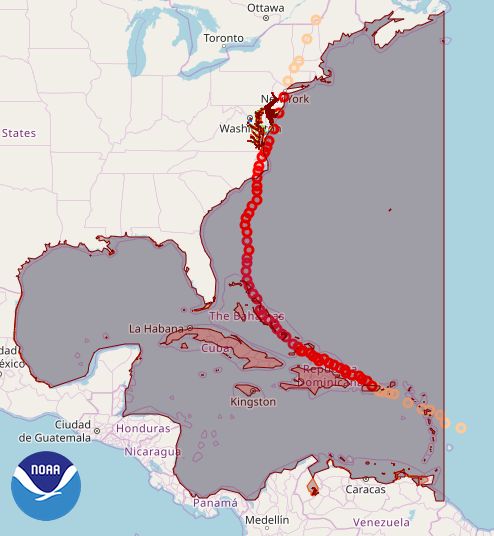
Fig. 1a: Model domain covers the whole US east coast.
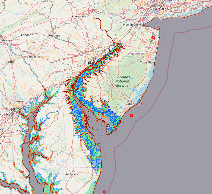
Fig. 1b: Model has very high resolution mesh on the Delaware Bay region.
In this study, all the National Water Model river segments were included in the model set-up. This includes river segments that could be dry most times of the year and only get flooded during the intense precipitation events. This model set-up also includes the effect of baroclinicity of the ocean therefore, effects of ocean related inundation (e.g. storm surge) are resolved fully.
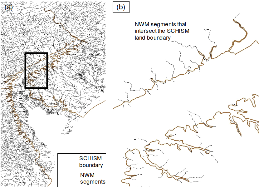
Fig. 2: On left: All of the NWM stream network in the Delaware region. On right: NWM segments that intersect the SCHISM land boundary. These locations are being used to define stream discharge input in the coastal ocean model (inside the black rectangle). All model configurations and results are pre-decisional and for official use only.
An interactive web-based GIS viewer is available to see and interact with the results.
The left panel represents the Total Water Level above the ground (inundation level) including NWM discharges and Precipitation, and
The right panel represent the extra inundation due to compound inland-coastal and freshwater flooding (by subtracting total water surface elevation of full 3D case without NWM and precipitation from the one that includes NWM and precipitation)).
Figs 4 and 5 show that the effects of compound flooding could increase the inundation level (water above the ground) more than 2 meters due to compound inland-coastal flooding and backwater effects. The model also captured inland flooding events away from Delaware Bay main branch where the compound coastal and freshwater flooding are not the prime cause of the flooding ( i.e. inland river-related flooding).
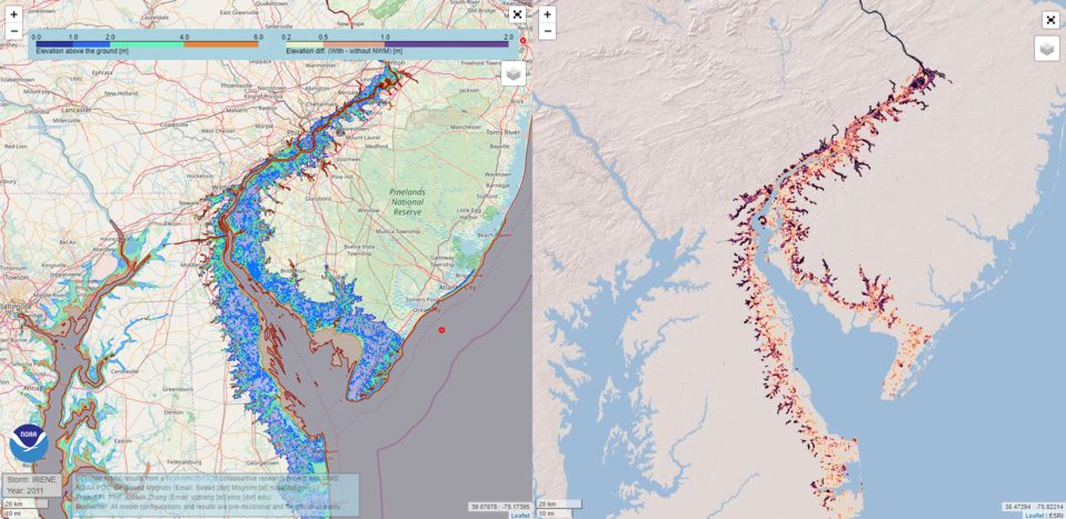
Fig. 3: Delaware Bay region. Left panel represents the Total Water Level above the ground including NWM discharges and Precipitation. The right panel represent the extra inundation due to compound inland-coastal and freshwater flooding (by subtracting total water surface elevation of full 3D case without NWM and precipitation from the one that includes NWM and precipitation). All model configurations and results are pre-decisional and for official use only.
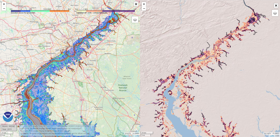
Fig. 4: North part of Delaware bay. Left panel represents the Total Water Level above the ground including NWM discharges and Precipitation. The right panel represent the extra inundation due to compound inland-coastal and freshwater flooding (by subtracting total water surface elevation of full 3D case without NWM and precipitation from the one that includes NWM and precipitation). All model configurations and results are pre-decisional and for official use only.
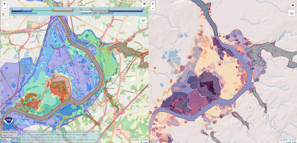
Fig. 5: Trenton, NJ. Left panel represents the Total Water Level above the ground including NWM discharges and Precipitation. The right panel represent the extra inundation due to compound inland-coastal and freshwater flooding (by subtracting total water surface elevation of full 3D case without NWM and precipitation from the one that includes NWM and precipitation). All model configurations and results are pre-decisional and for official use only.
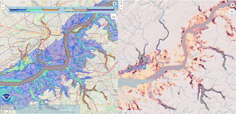
Fig. 6: Philadelphia Airport region (blue marker). Left panel represents the Total Water Level above the ground including NWM discharges and Precipitation. The right panel represent the extra inundation due to compound inland-coastal and freshwater flooding (by subtracting total water surface elevation of full 3D case without NWM and precipitation from the one that includes NWM and precipitation). All model configurations and results are pre-decisional and for official use only.
Contact: Saeed.Moghimi@noaa.gov
Disclaimer: All model configurations and results are pre-decisional and for official use only.
Coastal Ocean Models